Pick a rider profile (with kids, relaxed, or anything), set your surface and separation constraints, and Trazo plans an A to B route or a distance-targeted loop on a stress-aware map. It runs entirely in the browser, with turn-by-turn directions and GPX export. Live today across four markets in three states: Fort Collins and the Denver metro area (Denver, Boulder, and the Front Range towns) in Colorado, Hilton Head in South Carolina, and the Triangle (Raleigh, Durham, and Chapel Hill) in North Carolina.
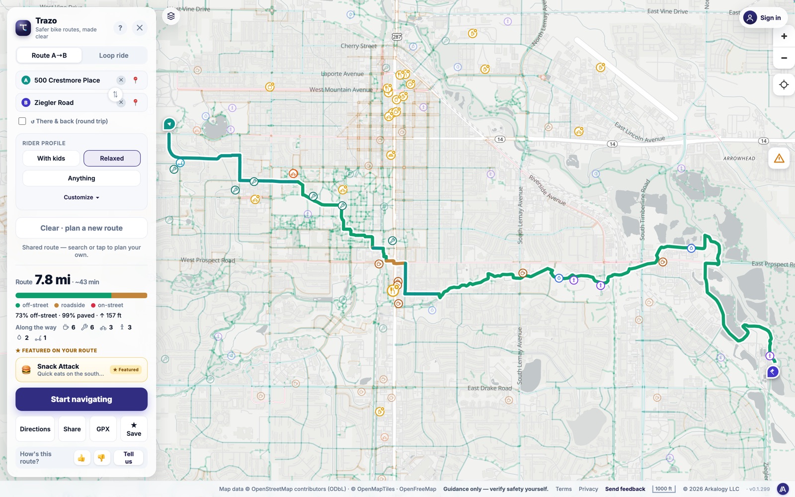
A real low-stress route, A to B: 7.8 miles, 73% off-street, with distance, time, and a turn-by-turn cue sheet.
Most bike directions optimize for fastest. Almost none optimize for how safe or pleasant the ride actually feels. Trazo plans around traffic stress, surface, and separation, so the route fits the rider, not the other way around.
Where the idea came from
Trazo started with us. We are newly biking parents, and when we went looking for safe, varied routes for family rides, we could not find a planner that thought about the things that actually decide whether a ride is comfortable: traffic stress, surface, and how far you are from moving cars.
Open any mapping app, ask for cycling directions, and you get the fastest line from A to B. That answer is fine if you are a confident commuter on a road bike. It is the wrong answer for a parent towing a kid trailer, a relaxed weekend rider, or anyone who would rather add a mile than share a lane with 45 mph traffic.
The information that actually decides whether a ride is comfortable is mostly invisible in those apps. Is this a protected path or a painted line next to moving cars? Is the surface paved or loose gravel? Does this trail actually connect, or does it dump you onto a busy arterial halfway through? And sometimes the goal is not a destination at all. It is a loop: "give me a pleasant 10 miles that brings me back home."
The real question for many riders is not what is the fastest way there. It is what is the calmest way there, on the surface I want, and can you bring me back if I just want to ride.
That gap is where Trazo began. The first city was Fort Collins, Colorado: a flat valley with an unusually connected web of trails, which made it the perfect place to prove that a comfort-first route planner could be genuinely useful.
What it does
Trazo turns those invisible factors into the inputs you plan with. You tell it who is riding and what you will tolerate, and it does the rest.
Rider profiles
One tap picks the comfort level: With kids (only the calmest, separated paths), Relaxed (low-stress streets and trails), or Anything (the network is yours). The profile reshapes every route Trazo returns.
Surface and separation constraints
Choose how far you want to stay from cars (off-street only, quiet streets, or busy roads OK) and which surfaces you will ride (paved only, or paved plus gravel and dirt). A "prefer flat" toggle favors a gentler climb.
A to B routing and distance loops
Plan point-to-point with optional waypoints and a there-and-back option, or switch to Loop mode, set a target distance, and Trazo generates a ride that comes back to where you started. Loops are the answer to "I just want to ride for a while," not "get me somewhere."
Turn-by-turn cue sheet and GPX export
Every route comes with turn-by-turn directions, an elevation profile, and busy-crossing alerts. Export the route as GPX to take it onto a head unit or another app, or follow it in-app with voice cues.
See only your network
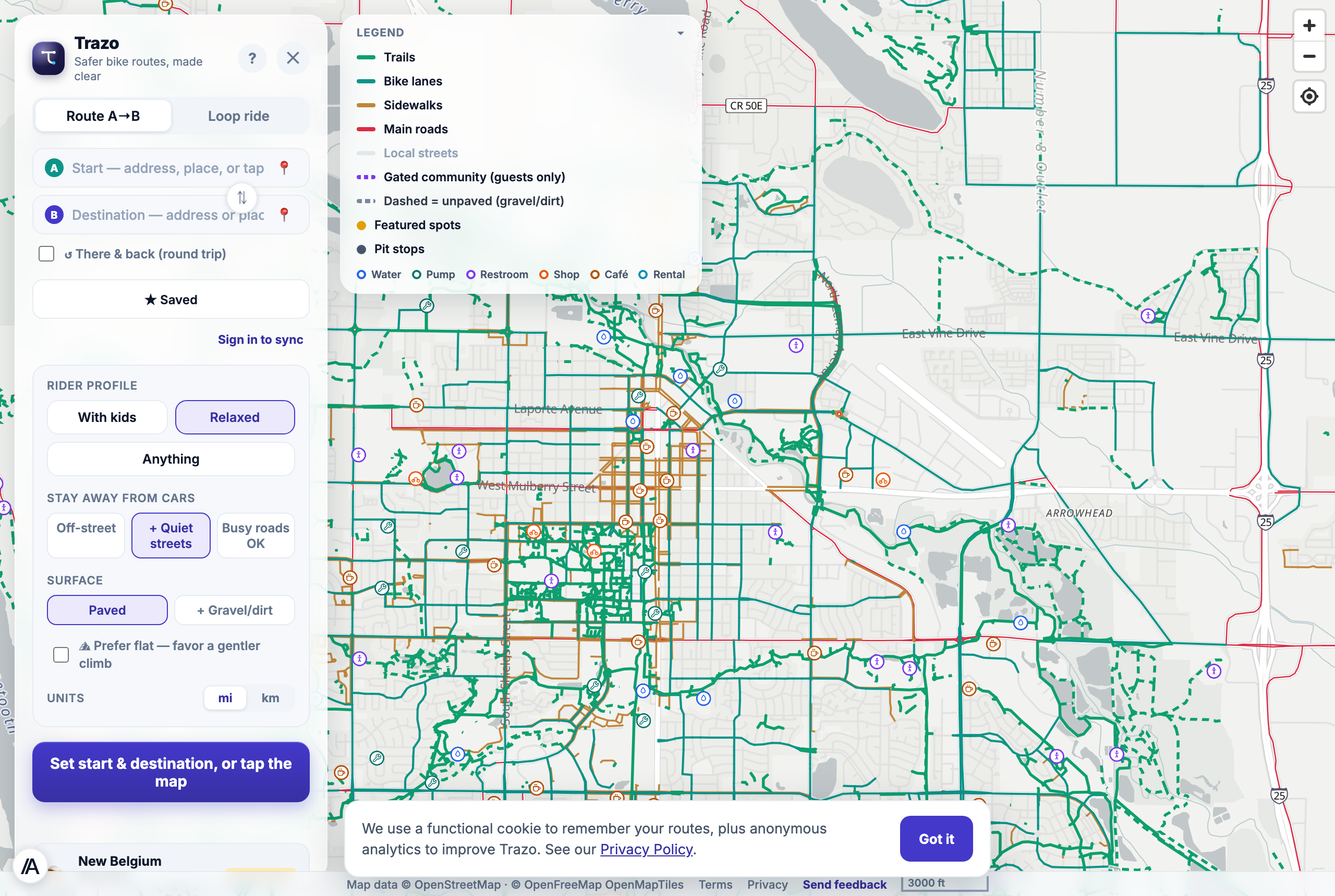
The whole map is colored by stress, surface, and separation, so you can read the city at a glance. Filter it down to "show me only the paths I would actually ride," and the noise disappears. Pit stops (water, restrooms, bike shops, cafes) and featured local spots ride along.
Built per city
Each market is its own bundle. Fort Collins, the Denver metro area, Hilton Head, and the Triangle all run live on the same architecture, and a new market slots in without forking the app.
trazo.bike/fort-collins/map
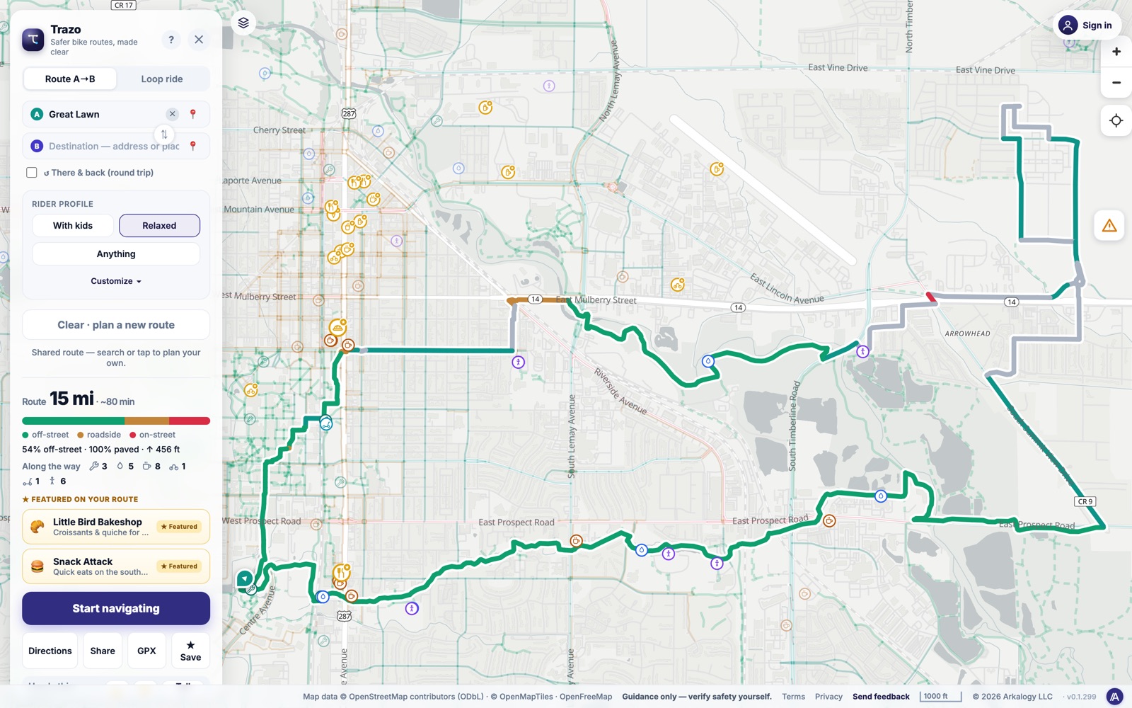
A distance-targeted loop that brings you back to where you started.
trazo.bike/fort-collins/map
The whole city, colored by traffic stress and surface.
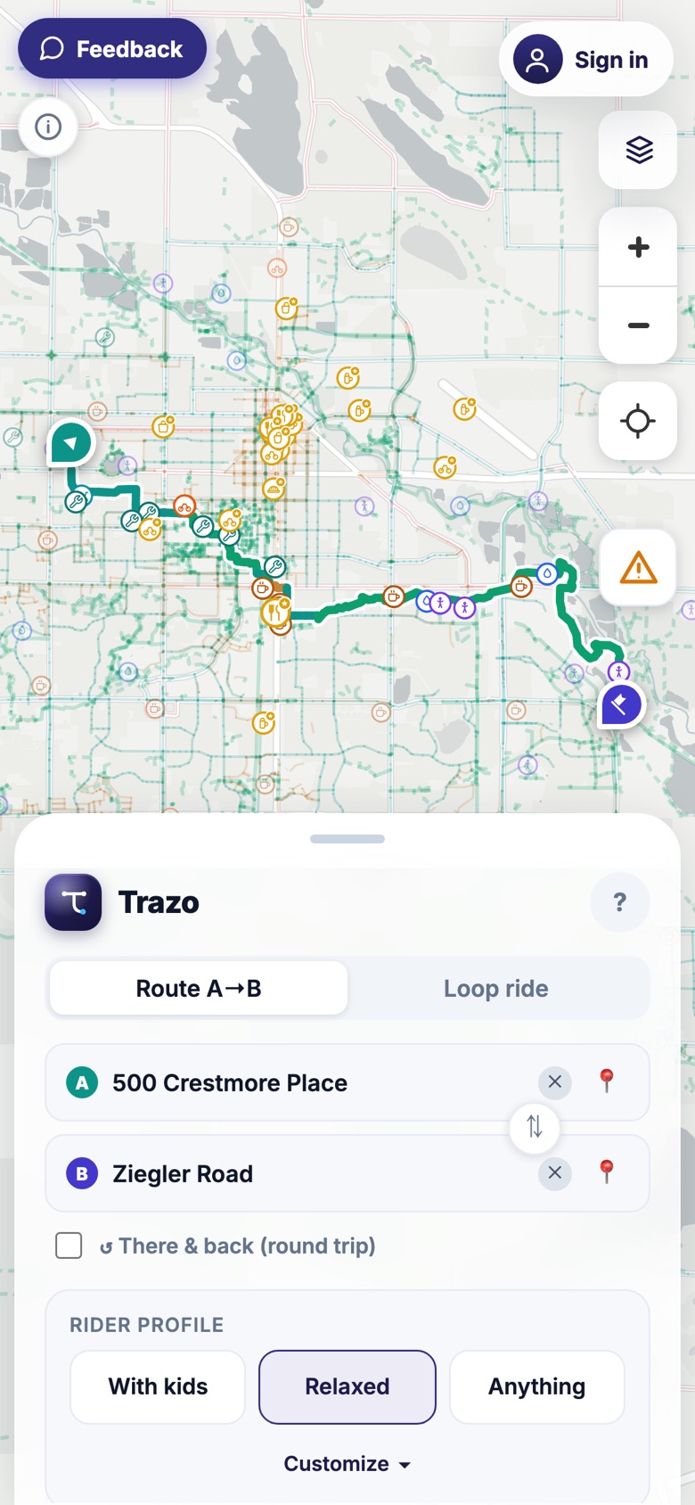
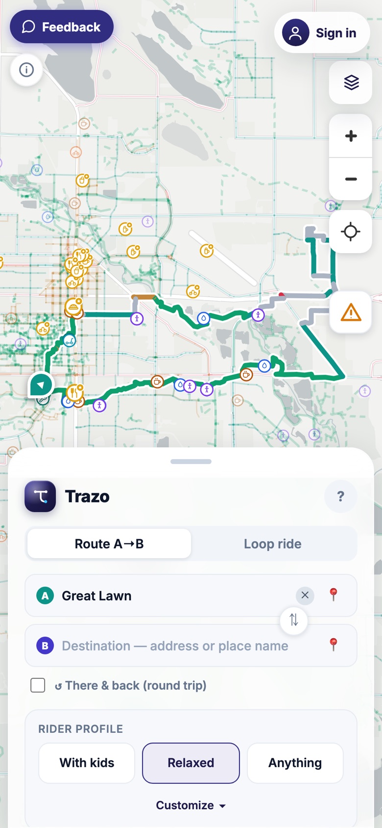
The whole thing is built for a phone in your hand, not a desktop shrunk to fit. The map fills the screen, and the controls (your start and finish, your rider profile, your surface and separation constraints) live in a sheet you thumb up from the bottom. Big touch targets, one-handed reach, no menus to dig through.
There is nothing to install to use it, because it runs in the browser. Add it to your home screen and it sits one tap away, opening straight into the map. Plan a route on the couch, scan the QR code to hand it to your phone, and head out.
On the bike, turn-by-turn directions read out as voice cues so your eyes stay on the road, and any route exports to GPX for a bike computer. The whole experience was designed for the moment that actually matters: standing over the bike, deciding where to go.
The planner on a phone: full-screen map, controls in a bottom sheet.
Loop mode on mobile, the distance target a thumb away.
How it was built, and why
The hard part of Trazo is not drawing lines on a map. It is encoding what "comfortable" means into data, then routing on it fast enough to feel instant. A few decisions shaped the product:
1
A routing graph that knows how a road feels. A build pipeline takes OpenStreetMap data and classifies every edge by surface (paved or soft), facility type, separation (off-street, roadside, or on-road), and a Level of Traffic Stress rating (LTS, the bike-planning field's standard 1 to 4 comfort scale). That classification is the product. It is what lets a "with kids" route differ from an "anything" route over the exact same streets.
2
Comfort-first routing, owned end to end. Routing uses a custom Dijkstra engine weighted by that stress and surface data, plus loop generation for distance-targeted rides. Trazo does not lean on a third-party routing service, because the comfort weighting is the whole point. Owning the engine means tuning our own knobs, not someone else's.
3
A colored overlay from open city data. The stress-and-surface map you read at a glance is rendered from the routing graph, enriched with city GIS open data for bike facilities and trails. The result is a map that explains itself before you have planned anything.
4
Static hosting, one app per city by path. Trazo is a MapLibre GL web app served as static files on Cloudflare Pages, with a path-based per-city structure so a new market is a new bundle, not a new codebase. No app store, no install, no signup to plan a ride.
Honest about what it can promise
The most important design decision in Trazo is not a feature. It is what the product refuses to claim.
The stress and separation ratings are inferred from open data, not field-verified. Trazo says so, plainly. It is guidance, and you verify safety yourself. A route planner that quietly implied "this is guaranteed safe" would be making a promise it cannot keep, especially to the parent it is trying to serve.
Why not just use Google Maps or Strava?
Plenty of apps will draw a bike route. The difference is what they optimize for.
Google and Apple Maps optimize for fastest, not calmest
They will happily route a kid trailer down a four-lane arterial because it shaves two minutes. Whether a segment is a protected path or a painted line beside moving traffic is not something they treat as a first-class input. For Trazo, that difference is the whole point.
Strava is built for training, not for planning a comfortable ride
Heatmaps and segments are great for athletes chasing times. They do not answer "what is the calmest way to get my family across town," and they assume you already know where you are going.
Trazo plans around comfort, and gives you loops
Pick who is riding, and every route is filtered by traffic stress, surface, and separation. Ask for a distance-targeted loop and it brings you back home. No account, no subscription, no app to install. Just a map that already speaks the language of how a ride actually feels.
Every bike-friendly town is a market
A record 112 million Americans rode a bike in 2024, the highest share in a decade, and for the first time the top reason people ride is recreation, not errands or commuting (PeopleForBikes, 2024). But the number that matters most to Trazo is a different one: 53% of riders say their biggest worry is being hit by a car. The barrier to riding more is not fitness or interest. It is comfort and safety, which is exactly what Trazo plans around.
The everyday and family riders who make up the bulk of those 112 million are not chasing segments or race times. They want a calm, pleasant way to get there, or a good loop that brings them home. That rider is who Trazo is built for.
The places that fit Trazo keep multiplying. The League of American Bicyclists counts 460 Bicycle Friendly Communities, home to about 76 million people (2025), and the number of US cities PeopleForBikes rates as genuinely good for biking has climbed from 33 in 2019 to 234 in 2025. Trazo's four live markets already span that spectrum: Platinum-rated Fort Collins and Boulder, the wider Denver metro, a Gold-rated island destination in Hilton Head, and the fast-growing greenway network of the Triangle. Each new market is a new routing graph on the same architecture, not a new app.
3rider profiles
A to Band distance loops
4markets live, 3 states
A comfort-first take on bike routing: pick who is riding, set your constraints, and get a route that actually fits the day. Live on the web, no install required.